Global Data
The following data may be used to help build your SWAT+ and SWAT models.
Weather Data
- Global Weather Data
Please contact pdaggupa@uoguelph.ca for further queries and information - Global CHIRPS/CHIRTS Weather Data
SWAT-formatted CHIRPS (precipitation) and CHIRTS (temperature) data by continent - SWAT+ Global Weather Generator Database
- ArcSWAT 2012 Global Weather Database
Contains monthly weather data covering the entire globe that can be used with ArcSWAT. Please read the import instructions and watch a short video before installing. More information about CFSR data. - NOAA Climate Data for the US 1950-2009
Hosted by USDA-ARS, formatted for SWAT - China Meteorological Assimilation Driving Datasets
Public datasets for the SWAT model - Spain Weather Datasets for SWAT
Weather generator databases, rainfall and temperature data
Soil Data
- SWAT+ US SSURGO (v2023) & STATSGO Soils Database
Updated December 2025- Download Tiff (~2.5 GB) - If used with the DB above, there will be no missing MUIDs
- March 2022 old version (missing MUIDS)
- SWAT US SSURGO Soils Database
Updated March 2022- Watch a video on how to prepare SSURGO data for ArcSWAT
- Using SSURGO soil data with QSWAT and QSWAT+
- Note: file updated to remove "Notes" column 2025-07-01
Additional Data
Please note: we advise only using the landuse and soil maps below when nothing better is available.
Landuse Maps
The landuse maps below come in the form of zip files containing 1 or more tiles for each continent. They come in two resolutions, the originals at approximately 400 meters (at the equator) and the resampled at 800 meters. The first are a little more accurate but the they take some time to load and minipulate. You may prefer to use the resampled ones at least while you are learning or experimenting.
- Africa (original) / Africa (resampled)
- Australia/Pacific (original) / Australia/Pacific (resampled)
- Europe/Asia (original) / Europe/Asia (resampled)
- North America (original) / North America (resampled)
- South America (original) / South America (resampled)
Landuse data was constructed from the USGS Global Land Cover Characterization (GLCC) database.
Soil Maps
The soil maps below come in the form of zip files containing 1 or more tiles for each continent.
Also available are some notes and a readme file from the FAO, the source of the soil data.
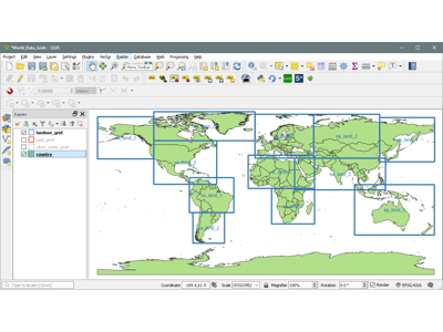
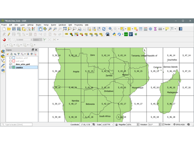
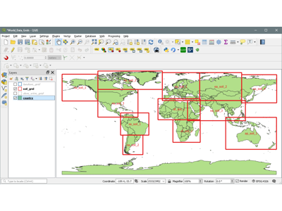
World Data Grids
This is a QGIS project contained in a zip archive that allows you to graphically select the DEMs, landuse, and soil maps that you need for your location. Just unzip the archive and open the project file World_Data_Grids.qgs in QGIS.
Lookup Tables
The lookup tables (global_landuses and global_soils) are supplied with QSWAT+ in the project database, as is the soil database (global_usersoil). The landuses are all defined in the standard SWAT+ plant database, also supplied with QSWAT+